On a bitterly cold Saturday night in early February, when most of the Hamptons had retreated indoors to escape temperatures that hadn’t been seen in over a decade, something broke in Napeague Harbor. The frozen waters of Gardiners Bay—solid ice for the first time since 2015—finally accomplished what 70 years of storms, hurricanes, nor’easters, and relentless coastal erosion could not: they killed the stilt house.
Located at 163 Mulford Lane in Amagansett’s Lazy Point section, the small one-story structure had stood on wooden pilings above the water since the 1940s or 1950s, weathering every storm that nature could throw at it. Originally a fisherman’s shack, it evolved into one of Long Island’s most photographed and beloved landmarks—a haunting silhouette visible from Mulford Lane’s end, perfectly framed against sunsets and, in its final weeks, the Northern Lights.
Then Winter Storm Fern arrived, bringing with it the coldest temperatures the Northeast had experienced in years. As the bay froze solid around the pilings, the expanding ice created pressures the aging wood simply couldn’t withstand. On the night of February 1, 2026, the wooden posts that had held the house aloft for generations snapped. The structure collapsed into the icy water, marking the end of an era and offering a stark preview of what climate change holds for the Hamptons’ coastal real estate empire.
This is the story of how an icon died—and what its death means for a coastline already losing its battle with rising seas.
The Final Hours: Winter Storm Fern’s Lethal Embrace
Understanding what killed the stilt house requires understanding Winter Storm Fern itself—one of the most expansive and deadly winter storms to strike North America in recent memory.
The Storm’s Devastating Path
Developing from an upper-level low off the California and Mexico coast on January 22, 2026, Winter Storm Fern (unofficially named by The Weather Channel) moved inland over southwestern Texas before meeting a massive Arctic cold air mass. The collision caused rapid intensification.
By the Numbers:
- Geographic Span: Over 2,000 miles from Arizona to New England
- States Affected: 30+ states under NWS watches, warnings, or advisories
- Emergency Declarations: 24 states declared emergencies
- People Impacted: Approximately 190 million Americans
- Death Toll: 85 people nationwide
- Power Outages: Over 1 million customers, concentrated in the South
- Economic Damage: Estimated at $4+ billion
The Northeast Impact
By January 25, Fern had transitioned into a nor’easter as it reached the Northeast, bringing the heaviest snowfall some cities had seen in a decade:
- Baltimore: 11.3 inches (heaviest since Winter Storm Jonas, January 2016)
- Philadelphia: 9.3 inches (heaviest in 10 years)
- Pittsburgh: 11.2 inches (heaviest since “Snowmageddon,” February 2010)
- Toronto: 56 centimeters (22 inches), breaking a record that stood since 1944
- Indianapolis: 11.1 inches (heaviest in 12 years)
- Kittery, Maine: 27.8 inches
Cornell climatologist Jessica Spaccio explained the storm’s unique severity: “It’s not unusual to have storm systems in the South, but the extent and extremeness of the cold was.”
The Freeze That Changed Everything
For Long Island’s coastal communities, the most significant impact wasn’t the snow—it was the cold that lingered after. Gardiners Bay, which separates the North Fork from the South Fork, froze solid for the first time since 2015.
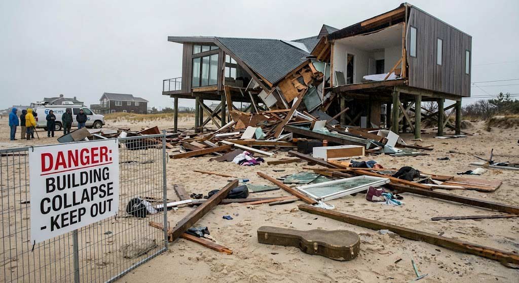
This seemingly minor detail proved catastrophic for the Lazy Point stilt house. Photographer James Katsipis, a Montauk native, captured the aftermath: the house sitting in a frozen wasteland of ice, no longer suspended gracefully above water but partially submerged in a deadly embrace of ice floes.
The physics were simple and brutal. As water freezes, it expands. The ice forming around the wooden pilings created immense pressure—pressure that increased as temperatures remained below freezing for days. The wood, weakened by decades of exposure to saltwater, simply couldn’t withstand the force.
On Saturday night, February 1, the pilings snapped.
By Sunday morning, the iconic silhouette was gone. In its place: a broken structure lying awkwardly in the ice, another victim of a climate that increasingly swings between extremes.
From Fisherman’s Shack to Instagram Icon: The House’s 70-Year Journey
To understand what was lost, you need to understand what the stilt house meant—and how it survived as long as it did.
The Early Years: A Working Structure
Built sometime in the 1940s or 1950s (exact records are unclear), the house began life as a simple fisherman’s shack. At the time, it sat on dry land, a modest structure serving a practical purpose in a fishing community.
Lazy Point, part of Amagansett in the Town of East Hampton, was a working waterfront. Fishermen needed places to store gear, prepare catches, and occasionally shelter from storms. The house at 163 Mulford Lane was one such structure—unremarkable except for its location.
Then the shoreline began to retreat.
The Great Transformation: When Land Became Water
Coastal erosion is nothing new to Long Island. The island’s south shore has been retreating for centuries. But the pace accelerated dramatically in the latter half of the 20th century.
According to local accounts and visible evidence, the north-facing shoreline beneath the stilt house gradually disappeared. What had been solid ground in the 1940s became beach in the 1960s, became tidal zone in the 1980s, and by approximately 2004, became open water.
The house didn’t move. The land did.
By 2004, the structure was fully surrounded by water, transformed from a house on land into a house on stilts. The metamorphosis was complete: a working building had become an accidental monument.
The Instagram Era: An Icon is Born
In the age of social media, striking visual subjects become cultural phenomena. The Lazy Point stilt house, with its lonely silhouette framed against water and sky, was Instagram gold.
Local photographer Christopher Lys kept a framed photo of the house in his office. “It’s one of those pictures that hung the test of time out here—people enjoyed it, and it was off the beaten path,” Lys said. “I wouldn’t be surprised if it’s going to be missed by the neighborhood, in a way, because it’s one of those identifiers of that area.”
James Katsipis, another local photographer, kayaked past the house hundreds of times over the years, capturing its changing moods through seasons and storms.
The house became a pilgrimage site for photographers and Instagrammers. Sunrise shots. Sunset shots. Storm shots. Moon shots. In its final weeks, it was photographed with the Northern Lights glowing behind it—a final, spectacular image before its collapse.
For kayakers and boaters, it served as a landmark—a navigational reference and a reminder that this coastline was once very different.
The Abandonment: A Structure Without an Owner
Despite its fame, the house had been uninhabited and disconnected from utilities for many years—possibly decades. Suffolk County tax records list Gary Ryan as the owner, though he apparently had no plans to maintain or occupy the structure.
Town officials classified it as abandoned. No one paid to preserve it. No one fought to save it. It simply… persisted, a ghost house suspended above the water, maintained only by inertia and the strength of aging wooden pilings.
From a legal and administrative perspective, it was a problem:
- Tax Status: Delinquent on property taxes
- Structural Status: Uninhabitable, no utilities
- Environmental Status: Potential debris hazard
- Regulatory Status: Built long before modern coastal construction codes
For town officials, it represented a ticking clock—a structure that would eventually fail, creating a debris field and environmental hazard. The only question was when.
The Erosion Crisis: How the Hamptons Lost Its Shore
The stilt house collapse isn’t an isolated incident. It’s a symptom of a coastline in crisis—one that threatens billions of dollars in real estate and the very existence of communities that define the Hamptons.
The Numbers Tell a Dire Story
East Hampton Town’s Coastal Assessment and Resiliency Plan (CARP), released in draft form, paints an ominous picture:
Sea Level Rise Projections:
- Last 100 Years: Approximately 1 foot of rise
- Next 30 Years: Projected 8 to 30 inches of additional rise
- By 2050s: 15 to 21 inches at Montauk
- By 2100: 32 to 54 inches at Montauk
Current Coastal Risk: The town’s current coastal risk level is classified as high and “will increase acutely in the near term and profoundly over the long term due to the effects of climate change.”
Beach Retreat:
- Currently: About half of the town’s 32 beaches are actively retreating
- Future: ALL beaches are predicted to retreat due to sea level rise
- Impact: Narrowing beaches, loss of habitat, increased dune and bluff erosion
Flood Risk:
- Probability: 60% chance of experiencing a flood event similar to the Hurricane of 1938 at least once in the next 30 years
- High Tide Flooding: Currently ~4 per year at Montauk; projected to increase to 50-90 days per year by the 2040s
The Ultimate Projection: “The currently projected range of sea level rise will transform East Hampton into a series of islands with permanent submergence of low-lying areas as early as 2070.”
The Erosion Mechanism: Understanding How Coastlines Retreat
Coastal erosion isn’t a single process—it’s the cumulative effect of multiple forces:
1. Sea Level Rise: As global temperatures increase, thermal expansion of ocean water and melting ice sheets cause sea levels to rise. Higher baseline water levels mean waves reach farther inland during storms.
2. Storm Surge: Hurricanes and nor’easters push massive volumes of water ashore. Even a Category 1 hurricane can cause storm surges of 4-5 feet; Category 5 storms can push surges above 15 feet.
3. Wave Action: Constant wave bombardment physically removes sand and soil. Each wave carries material seaward in its retreat.
4. Longshore Drift: Currents parallel to shore move sediment along the coastline. For Long Island, the dominant current flows counterclockwise (east to west), meaning beach sand migrates westward unless physically blocked.
5. Human Interference: Jetties, seawalls, and other “hardening” structures disrupt natural sediment flow. A jetty protecting one property often starves the beach immediately downdrift, accelerating erosion there.
The Historic Precedent: The Hurricane of 1938
The CARP’s reference to the Hurricane of 1938 isn’t random—it was the defining disaster in Long Island coastal history.
On September 21, 1938, a Category 3 hurricane made landfall on Long Island with virtually no warning (weather forecasting was primitive). The storm surge reached 10-15 feet in some areas, with waves topping 30 feet.
Impact Statistics:
- Deaths: Over 700 people killed across the Northeast
- Homes Destroyed: Thousands, particularly in beach communities
- Economic Damage: $400+ million (1938 dollars); $7+ billion in 2023 dollars
- Physical Changes: Entire barrier islands breached; inlets created; shorelines permanently altered
The hurricane demonstrated what a major storm could do to Long Island’s vulnerable coastline. The fact that there’s a 60% chance of a similar event in the next 30 years should terrify anyone with coastal property.
The Jetty Wars: How Engineering Made Things Worse
After the 1938 hurricane and subsequent storms in the 1950s, the Army Corps of Engineers developed the Fire Island to Montauk Point (FIMP) project—one of the nation’s first extensive erosion and hurricane defense projects.
The plan centered on constructing jetties (engineered structures extending perpendicular to shore) to trap sand and protect beaches.
The Theory: Jetties would interrupt longshore drift, causing sand to accumulate on the updrift side, building beaches.
The Reality: Jetties worked exactly as designed—on the updrift side. Downdrift beaches were starved of sand, accelerating erosion.
Lee Koppelman, a regional planning expert, watched from helicopters as each new jetty took “a bite of the beach behind it.” Houses washed into the ocean. The Sand n Surf restaurant slid into the water. An apartment complex’s swimming pool vanished.
Eventually, lawsuits halted jetty construction in 1970. But the damage was done—and the erosion continues.
The Contemporary Solution: Beach Nourishment
Today’s preferred approach is “beach nourishment”—dredging sand from offshore or other sources and pumping it onto eroding beaches.
Downtown Montauk Project:
- Volume: 450,000 cubic yards of sand
- Funding: Army Corps of Engineers (FIMP project)
- Controversy: Ditch Plains residents argue they should be included; Army Corps has historically refused, claiming Ditch Plains experiences flooding but not the wave erosion that justifies beach nourishment
Ditch Plains Situation: Recent storms (December 2023, January 2024) left the Ditch Plains beach profile “non-existent” down to hardpan. Dune breaches, flooding, and damage to homes and infrastructure followed. Governor Kathy Hochul authorized $3 million for stabilization, but the fundamental problem remains: the beach is retreating faster than it can be replenished.
The Lazy Point Lawsuit: When Neighbors Fight Over Sand
The stilt house wasn’t the only structure at risk in Lazy Point. Nearby property owners, facing similar erosion threats, installed large geotextile sandbags to fortify their homes—going against typical town environmental policy.
This prompted lawsuits from neighbors who claimed the sandbags blocked public beach access. The East Hampton Town Building Department eventually approved the installation of new geotextile cubes, with the understanding that a more permanent solution would be found within nine months.
As of the stilt house collapse, no permanent solution had been implemented.
Christopher Lys, observing the collapsed house, reflected on the broader implications: “That location or area has had multiple lawsuits recently, for other properties, but all I could think is that specific house falling into the water is a true harbinger of the area that we live in in the vulnerability of our shorelines.”
The Climate Change Connection: Why Extreme Cold and Warming are Both Threats
The irony of the stilt house collapse isn’t lost on climate scientists: a structure survived for 70 years through warming trends and sea level rise, only to be killed by extreme cold—which itself is likely linked to climate change.
The Polar Vortex Phenomenon
Winter Storm Fern’s intensity was amplified by Arctic air escaping from the polar vortex—a band of strong winds that normally contains cold air over the Arctic.
Research increasingly links polar vortex disruptions to climate change. As the Arctic warms faster than the rest of the planet (a phenomenon called “Arctic amplification”), the temperature gradient between the Arctic and mid-latitudes weakens. This can destabilize the polar vortex, allowing Arctic air to plunge southward.
The result: more frequent and severe cold snaps in places that aren’t equipped to handle them—places like Texas, which saw catastrophic power failures, and the Hamptons, which saw a bay freeze for the first time in over a decade.
The Dual Threat to Coastal Structures
Climate change creates a pincer movement on coastal infrastructure:
Threat 1: Chronic Stressors
- Sea level rise
- Increased storm frequency and intensity
- Warmer ocean temperatures (more fuel for hurricanes)
- Coastal erosion
- Saltwater intrusion
Threat 2: Acute Events
- Extreme cold snaps (like Winter Storm Fern)
- Flash flooding
- Rapid storm intensification
- Compound flooding (storm surge + rainfall + high tide)
The stilt house survived decades of Threat 1—the slow, grinding pressure of coastal erosion. It succumbed to Threat 2—an acute event that created forces the aging structure couldn’t withstand.
What the Science Predicts
Research published in the 2024 New York State Climate Impacts Assessment projects significant changes for Long Island:
Temperature:
- Continued warming across all seasons
- More frequent heat waves
- More variable winter temperatures (warmer on average, but with potential for extreme cold events)
Precipitation:
- 50% or greater increase in heavy precipitation in the Northeast
- 2-5% increase in winter precipitation per degree of warming
- More intense storms delivering larger volumes in shorter timeframes
Marine Changes:
- Rising sea surface temperatures (largest increases in summer and fall)
- Increasing frequency of marine heat waves
- Species migration (lobster moving north; southern species arriving)
- Declining oxygen in warmer waters
Coastal:
- Accelerating sea level rise
- Increasing high-tide flooding frequency
- Greater storm surge heights
- Accelerated beach erosion
- Loss of coastal wetlands
Cornell climatologist Samantha Borisoff noted that while Winter Storm Fern was well-forecasted, allowing preparation, the storm demonstrated that “extreme weather events will become increasingly volatile.”
The stilt house collapse is what that volatility looks like up close.
The Emergency Response: Racing Against Time and Ice
When the stilt house collapsed on February 1, it immediately became both a navigation hazard and an environmental threat.
The Immediate Danger
By Monday, February 3, East Hampton Town Building Inspector Richard Normoyle had designated the structure an “unsafe structure” that should be vacated under New York State Property Maintenance Code.
The Building Department placarded the site as unsafe. But “vacating” an abandoned structure already in the water was meaningless. The real issues were:
Navigation Hazard:
- Debris field in Napeague Harbor
- Risk to marine traffic
- Potential for further breakup and dispersal
Environmental Threat:
- Building materials (wood, nails, potential paint/chemicals) contaminating bay
- Debris washing into wetlands
- Harm to sensitive coastal ecosystems
Property Damage Risk:
- Ice movement could push debris toward other properties
- Further collapse could create larger debris field
The Emergency Authorization
East Hampton Town officials determined that emergency action was necessary. Town Supervisor Kathee Burke-Gonzalez explained: “Protecting public safety and our coastal environment is a responsibility we take seriously.”
The town submitted an Emergency Authorization request to the New York State Department of Environmental Conservation (DEC) to remove the structure without going through normal permitting processes, which can take months.
Councilmember Tom Flight described the coordination required: “This was a rapidly evolving situation that required close coordination across Town departments and with our state partners. Our focus has been to address the hazard quickly and responsibly, with a plan that protects public safety, reduces risks to navigation, and limits impacts to nearby wetlands and coastal waters.”
The Removal Plan
The town contracted Chesterfield Associates, Inc. to conduct barge-based containment and removal once conditions allowed safe mobilization.
Key Elements:
- Barge-based access only: No shoreline disturbance
- Debris boom: Containment measures to prevent material spreading into bay
- Timing: Weather-dependent; requires calm conditions and ice breakup
- Duration: Approximately 2 days once work begins
- Environmental protection: Minimize wetland and coastal water impacts
As of February 6, ice had broken up around the structure, and some debris was moving away from it, complicating removal efforts. The town anticipated beginning work on Tuesday, February 11, or Thursday, February 13, depending on weather.
Deputy Clerk for East Hampton Town Trustees Jim Grimes observed on February 6: “The ice has broken up around it. Looks like some debris is moving away from it.”
The challenge: removing a collapsed structure from a partially frozen bay without causing additional environmental damage or navigation hazards, all while working within a narrow window of acceptable weather conditions.
What the Collapse Means for Hamptons Real Estate
The stilt house was a minor structure—probably worth less than $100,000 if it could even be valued in its condition. But its collapse carries implications worth billions for Hamptons real estate.
The Economic Stakes
The Hamptons represents one of the most valuable coastal real estate markets in the United States:
- Median Home Prices (2026): $2.0M–$2.3M across the region
- East Hampton Village Median: $5.6 million
- Ultra-Prime Properties: $10M+ standard; many exceed $20M
- Property Tax Base: Billions of dollars dependent on coastal property values
A 2020 analysis warned: “Climate change is expected to bring constant floods that would tank property values, erode infrastructure, and sink tax revenue, all of which will make it harder to fund projects to battle the rising seas.”
Bloomberg’s investigation concluded that behind only central California, the Hamptons has the second-highest level of property tax revenue at risk among U.S. municipalities with high likelihood of chronic flooding in the next 12 years.
The Managed Retreat Debate
East Hampton’s CARP recommends policies to “guide and incentivize a ‘managed retreat’ of development away from shorelines.”
This euphemistic phrase masks a brutal reality: some properties will become uninhabitable and will need to be abandoned.
Managed Retreat Components:
- Zoning changes: Prohibiting new construction in high-risk zones
- Building code updates: Requiring coastal structures to meet higher standards
- Buyout programs: Government purchasing at-risk properties
- Relocation incentives: Encouraging development away from vulnerable areas
- Rolling easements: Allowing natural shoreline migration
Environmental advocate Adrienne Esposito of Citizens Campaign for the Environment is blunt: “We must make a strategic retreat. I suggest a regional approach—moving inland to higher ground.”
But “managed retreat” faces enormous political and economic obstacles:
Political Problems:
- Wealthy property owners with significant political influence
- Local governments dependent on property tax revenue
- Businesses built around coastal tourism
- Cultural identity tied to beach access
Economic Problems:
- Property values crash when retreat is acknowledged
- Banks unwilling to finance doomed properties
- Insurance increasingly unavailable or unaffordable
- Tax base erosion undermines municipal finances
Legal Problems:
- Property rights versus public safety
- “Takings” claims if government restricts use
- Liability for structures that harm others or environment
- Inconsistent enforcement across jurisdictions
The stilt house avoided all these problems by simply collapsing. Its owner faced no difficult decisions, no political fights, no legal battles. Nature made the decision.
The Precedent Effect
Every dramatic coastal collapse—whether a house, a beach club, or a restaurant—reinforces the reality that the Hamptons coastline is retreating.
This creates cascading effects:
Insurance Markets: Insurance companies aren’t sentimental. They analyze actuarial tables and decline to insure properties with high risk of loss. As coastal flood risk increases, insurance becomes:
- More expensive
- More restrictive (excluding flood coverage)
- Entirely unavailable for highest-risk properties
Mortgage Markets: Banks won’t finance homes that can’t be insured. As insurance evaporates, so does financing for buyers—even wealthy ones who could theoretically pay cash often use leverage for tax and investment purposes.
Sales Markets: Savvy buyers increasingly factor climate risk into purchase decisions. Properties with obvious vulnerabilities (low elevation, eroding bluffs, insufficient setbacks) face:
- Longer days on market
- Steeper price discounts
- More inspection contingencies
- More buyer walkways
Rental Markets: Even short-term rentals suffer. Why rent a beach house that might not be there next year? Or that requires evacuation insurance? Or that has sandbags and bulkheads destroying the beach aesthetic?
The Stilt House as Symbol
The Lazy Point stilt house, in its final form, was the perfect metaphor for Hamptons coastal real estate: a structure that should have been on solid ground, surrounded instead by water, maintained only by aging infrastructure, owned by someone who’d given up, admired for aesthetic reasons but functionally useless, and doomed to an inevitable collapse that everyone could see coming but no one prevented.
That it survived as long as it did—70 years from construction, 20+ years fully surrounded by water—speaks to both the quality of mid-century construction and the sheer stubbornness of wooden pilings in saltwater.
That it finally collapsed not from a hurricane or nor’easter but from the cold—from ice—speaks to the unpredictable nature of climate change impacts.
And that it died alone, abandoned, and unlamented by anyone except photographers mourning a lost subject… well, that might be the future for many Hamptons properties.
The Path Forward: Adaptation, Mitigation, or Denial?
The Hamptons faces a choice that every coastal community in America must eventually confront: adapt to the changing climate, mitigate the changes through engineering, or deny reality until catastrophe forces action.
The Adaptation Approach
Adaptation means accepting that the coastline is changing and modifying human activity accordingly.
Examples:
- Elevating structures: New construction on pilings or raised foundations (ironically, like the stilt house)
- Flood-resistant design: Wet-proofing, breakaway walls, water-resistant materials
- Retreat from high-risk zones: Not rebuilding destroyed structures; moving development inland
- Living shorelines: Natural barriers (wetlands, oyster reefs, dune systems) instead of hard engineering
- Land use planning: Zoning that prohibits development in flood-prone areas
Advantages:
- Works with nature rather than against it
- Often cheaper long-term than constant engineering fixes
- Preserves ecosystem services
- Acknowledges climate reality
Disadvantages:
- Requires accepting property value losses
- Politically difficult (people oppose being told where they can’t build)
- Benefits future generations more than current property owners
- Doesn’t protect existing development
The Mitigation Approach
Mitigation means engineering solutions to protect existing development from coastal hazards.
Examples:
- Beach nourishment: Pumping sand onto beaches (like the Montauk project)
- Seawalls and bulkheads: Hard structures to block wave action
- Offshore breakwaters: Submerged or floating barriers to reduce wave energy
- Dune restoration: Building and stabilizing protective dunes
- Drainage improvements: Preventing flooding from rainfall and high tides
Advantages:
- Protects existing investments
- Visible action reassures property owners
- Can be effective short-term
- Maintains tax base
Disadvantages:
- Expensive (the Montauk project alone involves hundreds of thousands of cubic yards of sand)
- Requires constant maintenance (beaches need renourishment every 5-10 years)
- Can worsen erosion downdrift
- Eventually overwhelmed by sea level rise
- Destroys natural beach dynamics
The Denial Approach
Denial means pretending the problem doesn’t exist and continuing business as usual.
Manifestations:
- Building closer to shoreline than prudent
- Opposing zoning restrictions
- Fighting insurance rate increases
- Minimizing climate change in public discourse
- Assuming engineering will always save the day
“Advantages”:
- No difficult decisions required
- No current sacrifice for future benefit
- Property values remain high (until they don’t)
- Political popularity (no one likes bad news)
Disadvantages:
- Catastrophic failures when reality intrudes
- Expensive emergency responses (like the stilt house removal)
- Taxpayer burden for bailouts
- Environmental damage
- Eventual complete property loss
The Hamptons’ Current Strategy: Uncomfortable Mix of All Three
East Hampton is simultaneously:
- Adapting: The CARP acknowledges retreat may be necessary; building codes tightening
- Mitigating: Beach nourishment projects; approving sandbags and geotextile cubes
- Denying: Still approving luxury development in flood zones; fighting comprehensive retreat
This incoherent approach is politically understandable but practically unsustainable. Eventually, the Hamptons—like every coastal community—will be forced to choose.
What History Teaches
The stilt house survived from the 1940s/50s to 2026—roughly 70-80 years. It witnessed:
- The 1938 Hurricane (if built before; otherwise its aftermath)
- The 1960s jetty construction
- The 1970s lawsuit wars
- The 1990s erosion catastrophes
- Hurricane Sandy (2012)
- Multiple nor’easters
It survived all of them. What it couldn’t survive was a cold snap that froze the bay solid.
The lesson: climate change doesn’t just mean warming. It means volatility, extremes, and unexpected failure modes.
No amount of engineering anticipates every scenario. Eventually, structures fail. Eventually, coastlines retreat. Eventually, the music stops.
The Final Image
In the weeks before its collapse, photographer James Katsipis captured the stilt house with the Northern Lights glowing behind it—a spectacular confluence of natural phenomena over an aging, doomed structure.
It was, in retrospect, the perfect final portrait: beauty and impermanence intertwined, natural wonder framing human hubris, the cosmos indifferent to our coastal real estate concerns.
The house is gone now, reduced to debris that the Town of East Hampton must remove from Napeague Harbor to protect navigation and the environment. The Northern Lights remain, appearing periodically as solar activity dictates. Gardiners Bay continues its slow transformation from water to ice and back again with each winter.
And the Hamptons coastline continues its inexorable retreat, claiming a few more inches of beach with each storm, a few more feet with each major hurricane, transforming waterfront property into simply… water.
The stilt house stood for 70 years as an accidental monument to persistence, to survival against odds, to the ability of simple wooden posts to defy erosion and storms and time itself. Its collapse reminds us that eventually, inevitably, the bill comes due.
The music has stopped. The dance is over. The question now is whether the Hamptons will learn the lesson before more icons fall into the rising sea—or whether, like the stilt house’s owner, we’ll simply abandon what can’t be saved and wait for nature to render the final verdict.
On a frozen bay in early February 2026, nature spoke clearly. The question is whether anyone’s listening.
Related Articles:
- East Hampton’s Coastal Assessment and Resiliency Plan: What Property Owners Need to Know
- Understanding Flood Insurance in High-Risk Coastal Zones
- The Complete Guide to Hamptons Beach Erosion and Property Values
- Climate Change Impact on Long Island Real Estate: A 20-Year Forecast
- Is Your Hamptons Property at Risk? New FEMA Flood Maps Explained
Further Reading & Sources:
- Behind The Hedges: “Town to Remove Collapsed Stilt House Under Emergency Order” (Feb 6, 2026)
- The East Hampton Star: “An Ominous Outlook for Coastal Areas” (CARP Draft Plan)
- New York State Climate Impacts Assessment: “Climate Impact Spotlight: The Long Island Region” (2024)
- Wikipedia: “January 23–27, 2026 North American Winter Storm”
- Cornell Daily Sun: “The Science Behind Winter Storm Fern Explained” (Feb 10, 2026)
- Bloomberg: “Hamptons Real Estate Tries to Avoid Disaster With Extreme Climate-Proofing” (Oct 2021)
- Governor Hochul: “Resiliency Efforts to Protect Long Island from Extreme Storms”
- WSHU: “East Hampton’s Shoreline is in Danger Due to Sea Level Rise” (May 2022)