There are at least fourteen documented burial grounds for enslaved people on the North Shore. Eleven have houses on them now.
That number comes not from advocacy organizations but from the compiled findings of archaeological surveys, county deed research, and church record analysis conducted over the past three decades by academic researchers at Stony Brook University and the Three Village Historical Society. It is not an estimate meant to shock. It is a conservative figure, because “documented” requires evidence — a land deed that mentions a “negro burying ground,” a church register that records a burial location, an oral history that names a site — and much of the evidence was never created or has not survived.
What gets destroyed first, in the archaeology of dispossession, is the record that something existed.
Slavery on the North Shore: The Scale Most People Don’t Know
New York was a slave state. This fact sits uneasily in a regional identity built around abolitionism, the Underground Railroad, and the moral clarity of the Union cause, but it is simply true. By 1790, New York had more enslaved people than any state north of the Mason-Dixon line — roughly 21,000. Suffolk County’s enslaved population was distributed across the agricultural estates of the North Shore, where wealthy landowners ran operations requiring labor that wage workers, in the postwar economy of the eighteenth century, were too expensive to provide.
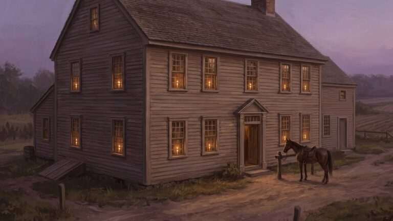
The Three Village area — Setauket, Stony Brook, Old Field — was home to some of the island’s largest slaveholding families. The Thompsons, the Smiths, the Strongs, the Woodhulls: these were not incidental slaveholders. They were the civic and economic leadership of the North Shore, and enslaved people built, maintained, and operated their estates. The Culper Ring — the revolutionary spy network that operated out of this exact geography — was partly enabled by an enslaved man named Cato, who passed intelligence through a network that has since been celebrated while his name was, until recently, largely absent from the telling.
The Culper Ring post gives the full story of how Setauket functioned as an intelligence operation during the Revolution. What it couldn’t fully address in that context is how the same households that ran the spy network were also slaveholding operations — and how the burial grounds of the people who made those households function have fared in the two and a half centuries since.
How Burial Grounds Disappear: A Technical Account
The legal mechanism by which enslaved people’s burial grounds became developable land operates in several layers, and understanding it matters if you want to understand why the problem is so difficult to remediate now.
First: enslaved people had no legal standing to hold property of any kind, including burial ground. Their graves existed at the sufferance of the landowner, on land the landowner controlled. When an estate was divided after death, the land on which an enslaved people’s cemetery stood transferred to heirs as ordinary real property. No deed covenant protected it. No legal instrument required its preservation.
Second: when New York gradually abolished slavery — the Gradual Emancipation Act of 1799 did not free existing enslaved adults, only their future children at age 25 for women and 28 for men; full emancipation didn’t come until 1827 — the communities of freedpeople that formed in the Three Village area were often landless and politically marginal. They could advocate for the preservation of burial grounds through the churches that had developed in their communities, but advocacy without legal standing has predictable outcomes.
Third: the church records that documented Black burials in this period were often kept in separate registers — “negro registers” — that were not maintained with the same institutional care as the main parish records. Some have been lost. Some were never transferred to centralized archives when congregations merged or buildings were demolished. Some survive but have never been fully transcribed or indexed.
The result is that by the time Long Island’s postwar development began absorbing the North Shore’s remaining agricultural and marginal land in the 1940s through 1970s, many of the burial grounds had no visible marker, no surviving legal documentation, and no community with sufficient institutional standing to contest their development.
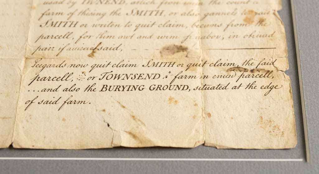
What the Land Deeds Say
Colonial and early Republic-era deeds for North Shore properties occasionally reference a “negro burying ground” or “burying ground for servants” as a feature of the land being conveyed. These references are not sympathetic — they’re informational, the way a deed might note a well or a stone wall. But they are evidence.
Researchers working through the Suffolk County Clerk’s deed index, cross-referencing against church burial registers and the findings of probate records, have identified specific parcels where such references appear. Some of these parcels remain open land — town parks, nature preserves, the grounds of historic estates now operated as museums. Others were subdivided in the twentieth century. The deed reference survives in the chain of title; the ground itself is under a foundation or a lawn.
The Three Village Cemetery Codes post addresses the existing marked cemeteries of the Three Village area — the ones that are known, mapped, and somewhat protected. What it can’t fully account for is what didn’t make it into the visible record. Marked graves are the archaeology of people who had enough standing to mark them. Unmarked burial grounds are the archaeology of everyone else.
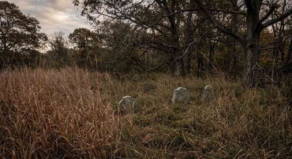
Ground-Penetrating Radar and What It Has Found
In the past twenty years, ground-penetrating radar has been used in at least two documented investigations of suspected burial sites in the Three Village area. The technology works by detecting anomalies in soil density and composition — a grave, even an unmarked one, produces a characteristic disturbance in the soil that GPR can identify with reasonable confidence.
The findings have been politically complicated. GPR surveys at one site in the Setauket area — the location is not publicly named by the researchers involved, for reasons connected to the sensitivity of the property situation — identified approximately thirty subsurface anomalies consistent with unmarked burials. The site has residential structures on part of it. The remaining open portion is privately owned.
No formal archaeological excavation has followed. Excavation of suspected burial sites requires a permit from the New York State Office of Parks, Recreation and Historic Preservation under the State Historic Preservation Act, and the permitting process for sites on private land involves the property owner’s consent. Property owners, for the entirely understandable reason that confirmed burial sites impose restrictions on land use, are not uniformly cooperative.
This is not a uniquely Long Island problem. Across the American South and, increasingly, in the North, GPR-assisted identification of unmarked enslaved people’s cemeteries has produced the same institutional friction: the technology can find what was lost; the legal and political framework for protecting what’s found was not designed with this use in mind.
The Preservation Framework and Its Limits
New York State’s burial law — specifically Section 6213 of the Education Law, which governs abandoned cemeteries — provides some protection for documented burial sites, even on private land. A cemetery that can be shown to exist on a parcel cannot simply be built over; the landowner must apply for authorization to relocate remains, a process that requires public notice and, in practice, some involvement from descendant communities.
The operative word is “documented.” A GPR anomaly is not, in the current legal framework, sufficient documentation to trigger Section 6213 protections. You need either a visible marker, a deed reference, a church record, or human remains confirmed by physical excavation — and excavation requires consent that owners may not provide.
The Monarch in the Wall post is, in part, about the physical evidence of Long Island’s past that survives in the landscape but goes unread — the fieldstone walls, the property line trees, the street names that compress centuries of ownership and dispossession into a single word. Unmarked burial grounds are the extreme case of that same phenomenon: evidence that exists in the ground, visible to the technology that looks for it, legally invisible to the framework designed to protect it.
The Descendant Communities
The African American communities that trace descent from the enslaved people of the North Shore have been doing this work longer than any university research project or GPR survey. The Bethel AME Church in Setauket, founded in the early nineteenth century by freedpeople from the Three Village area, has maintained oral traditions about burial locations that in some cases preceded and in other cases confirmed what the archival research found.
Community-based preservation efforts, including the work of the Setauket Neighborhood House and the Long Island African American Chamber of Commerce, have in recent years brought more formal research partners to the question. Stony Brook University’s history department has conducted oral history interviews with elderly community members — the kind of interviews that, a generation later, will no longer be possible. Some of those interviews name specific locations.
The gap between what the community knows and what the legal framework can protect remains wide. It narrows only when political will, institutional resources, and property owner cooperation converge at once, which is rare.
What Should Happen and What Probably Will
Advocacy groups, researchers, and preservation organizations have identified a set of practical steps that would meaningfully advance the situation. A comprehensive deed survey of North Shore properties using the deed language indicators researchers have already identified would produce a more complete map of known and suspected sites. County legislation establishing a formal process for the review of suspected burial sites identified through GPR — parallel to the process that already exists for sites identified through physical excavation — would give that map legal teeth. A descendant community consultation process, built into any development permit application in areas where deed evidence suggests historic burial use, would catch cases that fall through the existing framework.
None of this is technically complicated. It requires political will from town and county governments that have, historically, been more attentive to the concerns of residential property owners than to the concerns of descendant communities with no property at stake.
The Long Island History: 20 Moments That Shaped the Island post attempts to give the arc of the island’s history its full scope. The erasure of enslaved people’s burial grounds is not a footnote to that arc — it is structurally connected to the agricultural wealth, the estate building, and the social hierarchy that produced the North Shore landscape people now pay significant sums to live within.
You can’t fully account for the landscape without accounting for who built it and where they were buried. The ground holds the record even when the record was never meant to survive.
You Might Also Like:
- The Culper Ring of Setauket: How a Village on Long Island’s North Shore Outmaneuvered the British Empire
- The Monarch in the Wall: A Walking Guide to the Hidden Markers That Tell Long Island’s Entire History
- The Three Village Cemetery Codes: What the Symbols on North Shore Gravestones Actually Mean
Sources:
- Three Village Historical Society: www.threevillagehistoricalsociety.org
- Stony Brook University, Department of History, African American Heritage Project
- New York State Education Law §6213 (Abandoned Cemetery Law): www.dos.ny.gov/historic/cemetery
- New York State Office of Parks, Recreation and Historic Preservation, Archaeology Unit: www.parks.ny.gov/shpo/archeology
- Suffolk County Clerk’s Office, Deed Index (1700–1900): www.suffolkcountyny.gov/clerk
- McManus, Edgar J. A History of Negro Slavery in New York. Syracuse University Press, 1966.
- Hodges, Graham Russell. Root and Branch: African Americans in New York and East Jersey, 1613–1863. University of North Carolina Press, 1999.
- Berlin, Ira, and Leslie Harris, eds. Slavery in New York. New Press, 2005.
- Bethel AME Church, Setauket, NY: www.setauketbethelame.org