Four centuries of ambition, rebellion, and reinvention are carved into the stone, bronze, and timber of Long Island’s North Shore — and most people drive past them every single day without a second glance. In the English countryside, locals play a quiet game of spotting royal ciphers on red post boxes — the initials of Victoria, Edward, George, Elizabeth — each one a timestamp embedded in the everyday landscape. One twenty-minute walk through a village can reveal the entire arc of the British monarchy, hidden in plain sight on cast iron.
Long Island’s North Shore has its own version of this game, and it runs far deeper than a monarch’s monogram. From Native American place names still embedded in road signs to colonial gravestones with hand-carved death’s heads, from Revolutionary War cannon scars on church walls to Gilded Age gateposts built to intimidate the uninvited, the timeline of an entire civilization is encoded into the landscape between the Long Island Sound and Route 25A. You just need to know how to read it.
This is a guide to reading the walls.
The First Language: Place Names and the Setalcott Layer (Pre-1664)
The oldest markers on Long Island are not made of stone. They are spoken — embedded in the names of places that most residents pronounce without a second thought. Every town on the North Shore sits on land that was inhabited for thousands of years before the first English deed was signed, and the Setalcott and Nissequogue people left their vocabulary woven into the geography itself.
Mount Sinai, before it was Mount Sinai, was Nonowatuck — a Setalcott word meaning “the stream that dries up,” a description of the seasonal waterways that fed the harbor. The area was known to English colonists simply as “Old Mans,” a name shrouded in competing legends involving a swindled British major named John Gotherson and the notorious land speculator Captain John Scott. Archeological excavations at Hopkin’s Landing on Pipe Stave Hollow Road have uncovered shallow oval basins lined with fire-cracked rock, shell fragments, and stone tool debitage dating back approximately four thousand years (Mount Sinai School District Historical Records). The Setalcott inhabited this harbor in a self-sustaining community from roughly 2000 B.C. through the late 1600s, nourished by deer, bay scallops, and the sheltered coves of Long Island Sound.
These names are the first layer of the wall. Nissequogue, the river that defines Smithtown’s northern border. Setauket, derived from the Setalcott people who sold the land to Brookhaven Town in 1655. Poquott, the tiny incorporated village tucked against Port Jefferson Harbor. Drive Route 25A from Cold Spring Harbor to Wading River and you are tracing a corridor where English, Dutch, and indigenous nomenclature collide on every road sign — a palimpsest of languages that most commuters absorb without recognizing.
Look for it. The next time you pass a street sign with a name you cannot quite pronounce, you may be reading a word that predates the English language on this continent by millennia.
The Colonial Deed: Gravestones, Saltbox Houses, and the 1660s Footprint (1655–1776)
The second layer of markers is carved in sandstone and slate. Long Island’s colonial cemeteries are among the most overlooked historical artifacts on the eastern seaboard, and many of them sit in plain view — wedged between residential backyards, tucked behind church parking lots, and hidden at the ends of narrow unpaved trails.
In Setauket, the village green anchors one of the most concentrated collections of colonial-era markers in New York State. The Caroline Church of Brookhaven, built in 1729, is one of the oldest Episcopal churches on Long Island and still holds services today. Its graveyard contains headstones bearing the unmistakable iconography of early American folk art: winged death’s heads, hourglasses, and soul effigies that evolved from grim to hopeful across the eighteenth century. Stony Brook University’s Special Collections holds the archive of Dr. Richard F. Welch, whose lifetime study of Long Island gravestones (c.1680–1810) documented the regional carving traditions that connected local stonecutters to a broader New England network of artisans. These carved stones are not merely grave markers — they are a visual language revealing the theology, economics, and artistic sensibility of an entire era.
A twenty-minute walk from the Setauket village green takes you past the Thompson House, built in 1709, where Doctor Thompson treated members of the Culper Spy Ring. The Brewster House, perched on a knoll along Route 25A, dates to 1665 and sheltered seven generations of the Brewster family, including Revolutionary War patriot Caleb Brewster. These saltbox farmhouses — with their distinctive long, sloping rear rooflines — are architectural timestamps. Their asymmetrical profiles, central chimneys, and clapboard siding speak to the practical Puritan building traditions imported directly from Connecticut across the Sound.
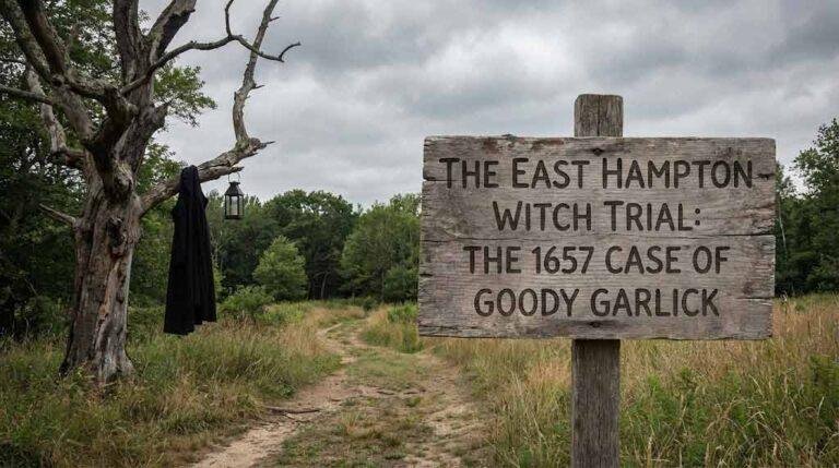
In Oyster Bay, the colonial cemeteries are even more dramatically hidden. The Fort Hill burying ground, accessible only by walking down a narrow unpaved trail alongside a private home and passing through a rusted, bolted gate, contains graves dating to 1668 — including that of Robert Townsend, codenamed “Culper Junior” in George Washington’s intelligence network (Atlas Obscura). The headstones carry colonial motifs — skulls, winged hourglasses — that have weathered into near-illegibility but remain readable to the trained eye.
These are the monarchs in the wall. Not the initials of a king on a post box, but the carved initials of colonial families on crumbling sandstone — each one a data point in the settlement timeline of an entire region.
The Revolution Underfoot: Battle Scars and Spy Trails (1776–1783)
The Revolutionary War left physical marks on Long Island that remain visible today if you know where to look. Unlike the grand battlefields of Gettysburg or Yorktown, Long Island’s war was fought in the shadows — through espionage, midnight raids, and the slow grinding pressure of British occupation. The scars are correspondingly subtle.
The Setauket Presbyterian Church, established in 1660 and rebuilt in 1812, sits on the site of the 1777 Battle of Setauket. British troops fortified the original church building, and Patriot forces fired upon it from behind a large glacial boulder that still sits on the village green — known today as Patriot’s Rock. A plaque placed by the Mayflower Chapter of the Daughters of the Revolution in 1927 marks the spot, but the rock itself is the artifact. Walk the green and you are standing on the exact ground where Continental soldiers mounted a cannon and exchanged fire with Loyalist troops barricaded inside a house of worship.
Route 25A itself is the war’s most overlooked monument. Formerly called the King’s Highway, the road now carries twenty-six historical markers designating it as the Washington Spy Trail. In 1790, President George Washington traveled this exact route by horse-drawn carriage to thank his Long Island supporters and the members of the Culper Spy Ring for their role in winning the war (Washington Spy Trail, washingtonspytrail.com). The road links Raynham Hall in Oyster Bay — where British Lt. Col. John Graves Simcoe quartered alongside the Townsend family — to the Nathan Hale Monument on Huntington’s Main Street, to the Stony Brook Grist Mill where British forces seized grain, to the battleground at Setauket.
Mount Sinai holds its own Revolutionary chapter, and it begins at Cedar Beach. On the night of November 21, 1780, Major Benjamin Tallmadge and eighty Continental Light Dragoons rowed across Long Island Sound in eight whaleboats from Fairfield, Connecticut, landing at what was then called Old Man’s Harbor. From there, they marched south across the island, stormed the British-held Manor of St. George near present-day Mastic Beach, captured fifty-three enemy soldiers, and burned three hundred tons of stockpiled British hay in Coram on their return march. Only one American was wounded — Sergeant Elijah Churchill, who for his bravery received a heart-shaped purple cloth badge from George Washington himself, the direct precursor to today’s Purple Heart (Journal of the American Revolution, 2020). The Benjamin Tallmadge Historic Trail, maintained by the Suffolk County Boy Scout Council, traces this exact route from Cedar Beach southward through Mount Sinai and across the island.
These trails, markers, and battle sites are not tourist attractions in any conventional sense. They are embedded in the daily commute, the weekend beach trip, the school pickup route. The war is still here, written in stone and bronze and road names. You just have to slow down enough to read it.
The Bull in the Road: Founding Legends Cast in Bronze (1665–1941)
At the fork of Routes 25 and 25A in Smithtown, a five-ton bronze bull named Whisper has stood since 1941, greeting every driver who enters the town from the west. The statue commemorates — or perhaps perpetuates — one of Long Island’s most colorful founding legends.
The story goes that Richard “Bull” Smith struck a deal with the Nissequogue people: he could claim all the land he could encircle in a single day while riding on the back of a bull. Smith chose the longest day of the year, set out from the Stony Brook Grist Mill at dawn, and rode the borders of what would become the entire Township of Smithtown. Bread and Cheese Hollow Road, which forms the western border between Smithtown and Huntington, is said to mark the spot where he stopped for his midday meal.
Local historians have largely debunked the ride itself. According to Smithtown’s official town historian Bradley Harris, the land was actually acquired through a deed of friendship from Grand Sachem Wyandanch to Lion Gardiner, who later transferred it to Smith. The 1665 Nicolls Patent from the colonial governor formalized the claim. But the legend endured — and in 1903, one of Smith’s descendants commissioned sculptor Charles Cary Rumsey to cast the bull in bronze. The statue sat in front of the Brooklyn Museum for nearly two decades before finally being installed in Smithtown in 1941. Local elementary students later named the bull “Whisper” through a newspaper contest.
Whisper is more than a roadside curiosity. The statue is a physical manifestation of how communities encode their origin stories into the landscape. Every town on the North Shore has its version — a founding myth, a boundary dispute, a colorful character — preserved not in a museum but in the infrastructure of daily life. The bull sits at a traffic intersection. You check your mirrors, signal your turn, and pass within ten feet of a seventeenth-century land dispute cast in bronze. That is the North Shore’s particular genius: history does not sit behind glass here. It sits in the road.
The Gilded Gate: Estate Architecture and the Language of Wealth (1890–1930)
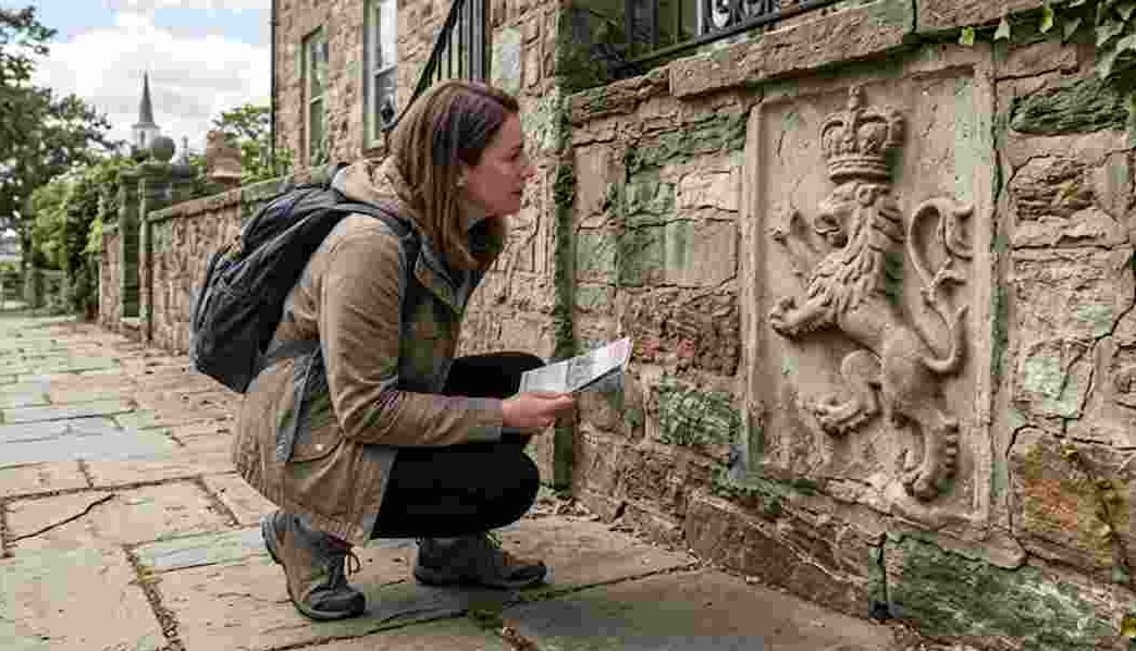
The most dramatic markers on the North Shore are the ones built to be seen — and then, paradoxically, to exclude. Between the 1890s and the 1930s, more than twelve hundred mansions were constructed along the Gold Coast by families whose names still define American wealth: Vanderbilt, Guggenheim, Phipps, Morgan, Kahn. Of those original estates, fewer than a third survive today (Treasures of New York, PBS THIRTEEN).
But the gateposts remain.
Drive Route 25A through Cold Spring Harbor, Huntington, and Centerport, and the road itself tells the story of the Gilded Age’s rise and fall. Stone pillars with wrought-iron gates mark driveways that once led to hundred-room châteaux. Many of these gates now open onto subdivisions, nursing facilities, or university campuses — the estates having been demolished, repurposed, or subdivided across the twentieth century. But the gateposts endure as a separate artifact, a grammar of wealth expressed in carved limestone, heraldic shields, and imported European ironwork.
Oheka Castle in Cold Spring Harbor, built by financier Otto Hermann Kahn on the highest point on Long Island, cost an estimated eleven million dollars in 1919 — roughly one hundred fifty-eight million in today’s currency. The estate covered 443 acres. At Old Westbury Gardens, John Shaffer Phipps promised his British fiancée a home resembling her family’s Battle Abbey estate, and architect George Crawley delivered a manor with twenty-three bedrooms and two hundred acres of formal gardens. On the Guggenheim Estate in Sands Point, Harry Guggenheim’s Falaise mansion was built in the style of a thirteenth-century Norman manor, complete with cobblestone courtyards and a round tower.
What the casual observer misses is the negative space around these estates. The North Shore barons used their influence to keep public roads and railroads in disrepair, discouraging uninvited visitors. Private guards patrolled estate borders. The geography of exclusion — the winding, narrow roads, the deliberate lack of signage, the stone walls running for miles along property lines — is itself a historical artifact. Robert Moses’s construction of the Northern State Parkway through this landscape in the mid-twentieth century was a direct challenge to this geography of privilege, forcing rights-of-way through private holdings and beginning the slow democratization of the North Shore corridor.
Today, many of these estates are open to the public as museums, parks, and event venues. But the original gateposts — some still bearing family crests, others stripped of their hardware and standing as mute sentinels — remain the most honest record of what the Gold Coast actually was. They are the equivalent of a royal cipher: a stamp of power pressed into the landscape, marking territory long after the territory has changed hands.
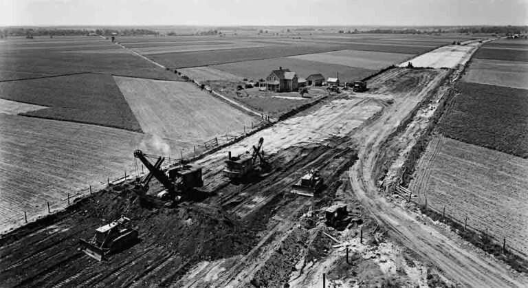
The Suburban Inscription: Midcentury Markers and the Transformation of Farmland (1945–1980)
The final layer of the wall is the most recent and perhaps the most invisible, because it is the layer we live inside. The postwar suburbanization of Long Island — the conversion of potato fields and peach orchards into cul-de-sacs and strip malls — left its own set of markers in the landscape, though they require a different kind of attention to read.
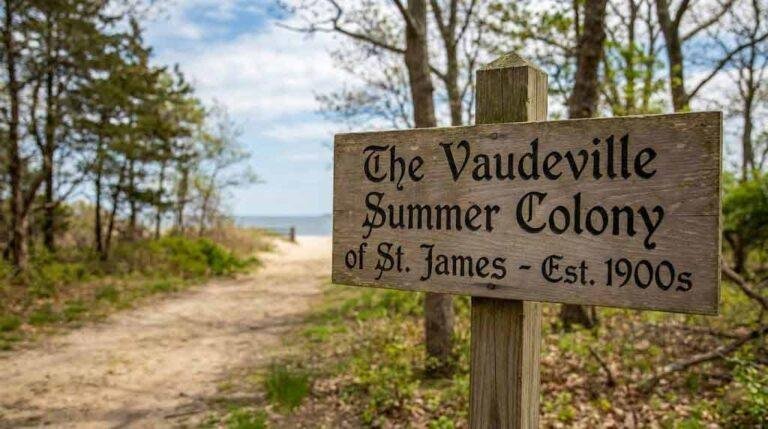
In Mount Sinai, the Davis Peach Farm stand on Route 25A was once a landmark so well known that it defined the hamlet for generations. The Long Island Rail Road ran through Mount Sinai from 1895 to 1939, bringing summer vacationers from the city to the harbor. The Chandler Estate, a forty-acre waterfront property that hosted Marilyn Monroe and Arthur Miller in the 1950s, was purchased by Suffolk County in 2001 and preserved as a public park. Crystal Brook Park, established in the nineteenth century as a health resort, transitioned through the twentieth century into one of the area’s residential neighborhoods.
These transitions are recorded in the architecture. Ranch houses and split-levels from the 1960s sit adjacent to colonial-era structures on North Country Road. A development called “the Colony” — a pocket of homes built for artists and writers — marks the hamlet’s brief identity as a creative retreat before the tide of conventional suburban development washed over it. The Mount Sinai Heritage Park, known locally as “the Wedge,” almost became a Home Depot before community advocacy preserved it as open space.
The suburban layer is the one most people take for granted, because it is the landscape of the present. But in fifty years, the ranch houses and their cul-de-sac geometries will be studied the way we now study saltbox farmhouses — as artifacts of a particular moment in American ambition, mass production, and the relentless eastward push of New York City’s influence across the island.
How to Walk It: A Twenty-Minute Guide to Reading Four Centuries
You do not need to be a historian to read the wall. You need twenty minutes and a willingness to look closely. Here is how to do it anywhere on the North Shore:
Start at the nearest cemetery. Find the oldest headstone and note its date, its material (slate, sandstone, marble, granite — each era had its preferred stone), and its iconography. Death’s heads are earliest. Willows and urns come later. Photographs on stone are twentieth century.
Walk to the nearest church. Note its construction date, typically engraved above the door or on a cornerstone. Churches on the North Shore frequently sit on sites that have held congregations since the 1660s, even when the current structure dates to the 1800s.
Follow Route 25A in either direction and count the blue-and-gold Washington Spy Trail markers. There are twenty-six of them along the full corridor, each one marking a site connected to the Revolutionary War intelligence network that helped win American independence.
Look for the gateposts. Stone pillars that seem disproportionately grand for the driveway they flank are almost certainly remnants of the Gold Coast era. Some still carry family crests. Others have been stripped bare but retain their scale — columns built for a thirty-room mansion now guarding a three-bedroom Cape.
Read the road names. Bread and Cheese Hollow. Pipe Stave Hollow. North Country Road. Old Field Road. Each one is a sentence fragment from a story that stretches back centuries — a reference to a colonial industry, a natural feature, a property boundary, or a founding legend.
This is the game. Once you start playing it, you cannot stop. Every walk becomes an excavation. Every drive down 25A becomes a timeline. The monarchs are in the wall, and they have been there all along — waiting for someone to slow down and read the inscription.
Sources:
- Mount Sinai Civic Association, “Our History” — mountsinaicivic.org/about
- Mount Sinai School District, “Mount Sinai History” — mtsinai.k12.ny.us
- Three Village Historical Society, Tri-Spy Tours — tvhs.org
- Washington Spy Trail — washingtonspytrail.com
- Atlas Obscura, “The Hidden Colonial Cemeteries of Oyster Bay” — atlasobscura.com
- Smithtown, NY Official Website, “History of Smithtown” — smithtownny.gov
- William G. Pomeroy Foundation, “Richard Smith” — wgpfoundation.org
- Journal of the American Revolution, “Major Benjamin Tallmadge and the Battle of Fort St. George” (2020) — allthingsliberty.com
- PBS THIRTEEN / Treasures of New York, “A Guide to Long Island’s Gold Coast Mansions” — thirteen.org
- Stony Brook University Library, “Long Island Gravestone Studies” — guides.library.stonybrook.edu
- Preservation Long Island — preservationlongisland.org
- Untapped New York, “12 Places to Discover in Setauket” — untappedcities.com
- Discover Long Island, “Revolutionary War Heritage Trail” — discoverlongisland.com