Barrier islands don’t stay where you put them. That’s the part nobody reads in the listing.
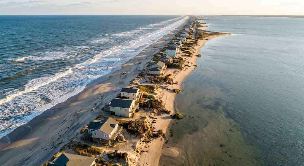
Fire Island is a thirty-one-mile strip of sand draped across the southern edge of Long Island, separating the Great South Bay from the Atlantic Ocean. It is narrow — half a mile at its widest — and it moves. Always has. Always will. The physics of it are straightforward: barrier islands exist in a constant state of sediment exchange with the sea, migrating westward, breaching, reforming, shifting their profiles in response to storms, currents, and the slow arithmetic of sea level rise. They are not fixed land. They are geological processes. They happen to be inhabitable at any given moment, but that moment has a shelf life.
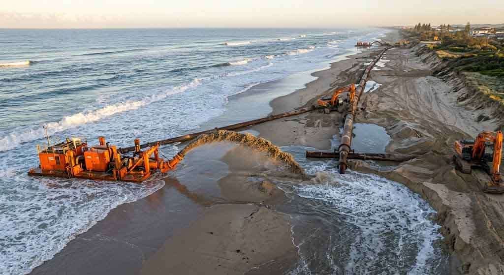
This is not obscure information. The U.S. Army Corps of Engineers has been documenting Fire Island’s retreat and erosion under the $2.4 billion Fire Island Inlet to Montauk Point (FIMP) project for years. The National Park Service manages much of the island as a federally protected national seashore precisely because of its ecological fragility. In January 2024, after Hurricane Lee and Tropical Storm Ophelia battered eastern Fire Island in September 2023, the Army Corps declared an emergency. Large sections of dunes from Ocean Bay Park to Davis Park were compromised. Homes and infrastructure were threatened. Emergency federal funding was mobilized. A $52 million contract went to a Houston dredging company to pump sand back onto beaches that the Atlantic had quietly claimed.
The ocean is not moved by this.
What a Barrier Island Actually Is
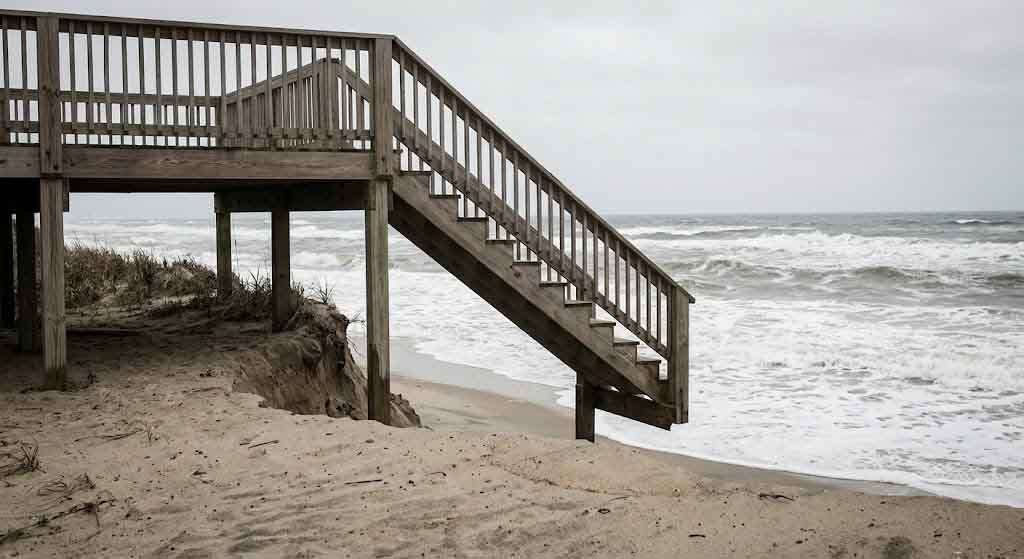
The technical definition is: a long, narrow, offshore deposit of sand parallel to the coast, typically separated from the mainland by a lagoon or bay. What that means on the ground is that you are standing on something the sea assembled and the sea can disassemble. Barrier islands have no bedrock foundation. They sit on sediment, and sediment is by definition mobile.
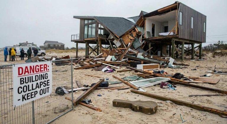
Fire Island’s topography has been altered repeatedly by storms over recorded history. Hurricane Sandy in 2012 was not an aberration — it was business as usual, at scale. The storm breached the island in two places, created a new inlet, and destroyed ninety homes outright. Eighty percent of the island’s structures flooded. A beach renourishment project completed in 2009 was widely credited with preventing worse damage, which is the right way to read that: without years of artificially pumped sand, the outcome would have been more catastrophic. The dunes that saved homes in 2012 were built by humans with federal money. They are not natural features. They are infrastructure. Expensive, temporary infrastructure that the ocean erodes on its own schedule.
After Sandy, the Army Corps began a systematic assessment of what it would take to maintain Fire Island as habitable land through the end of this century. Their estimate, factoring in sea level rise projections from NOAA of between two and seven feet by 2100, was sobering. The FIMP program funds beach replenishment at four-year intervals for thirty years. After those thirty years, there is no plan. The Army Corps told Fire Island News directly that they estimated erosion control needs up to one hundred years out, and the picture is not reassuring.
The Price Tag on the Fantasy
Real estate on Fire Island has not adjusted its pricing to reflect any of this. Homes in Fire Island Pines and Cherry Grove regularly sell in the high six figures, and multimillion-dollar properties are not unusual. The appeal is real: proximity to New York City, a car-free environment, architectural character, a distinctive community culture, waterfront access. People pay for all of that, and they pay a lot.
What they do not pay for, separately, is the ongoing cost of keeping the island from reverting to its natural state. That bill goes to the public. The FIMP project is 100% federally funded, drawn from the Disaster Relief Appropriations Act that followed Sandy. Governor Hochul committed additional state money in 2024. Suffolk County pitches in. The homeowners in various Fire Island communities pay into Erosion Control Districts through property tax levies, which provided some local contribution to the 2009 renourishment project — an estimated $6,020 per housing unit. But the big numbers, the hundreds of millions in Army Corps dredging, come from federal appropriations. The broader taxpaying public subsidizes the continued habitability of private property on a barrier island it mostly doesn’t visit.
There is nothing novel about this arrangement in American coastal real estate. The National Flood Insurance Program has subsidized below-market flood insurance for high-risk coastal properties for decades, a policy economists across the political spectrum have criticized as an incentive to build in exactly the places that shouldn’t be built in. Fire Island is a specific and vivid version of a national pattern. The risk is socialized. The asset appreciation goes to the private owner.
Paola Meyer, Associate Broker at Realty Connect USA, who works the Long Island market with a ground-level knowledge of how these coastal dynamics translate into real transactions, is direct about what buyers in these markets need to understand. Any purchase in a coastal flood zone is a purchase into a risk structure, and that structure is not fully priced into the asking price. Flood insurance, potential future assessments from local erosion taxing districts, and the long-term trajectory of sea level rise are all factors that belong in the financial analysis before an offer is made, not after. The romance of the barrier island is real. So is the physics.
The Particular Arrogance of the Foundation
There’s a specific kind of confidence required to build a permanent structure on a temporary landform. You have to believe, at some level, that the rules apply to everyone except you. That what the sand does to other houses will not happen to yours. That the investment is solid even when the ground literally is not.
The Sunken Forest on Fire Island, a dense grove of ancient holly, sassafras, and shadbush that has survived in the island’s interior for centuries, offers a useful counterpoint. It exists because it is low-lying, flexible, and part of the island’s natural hydrology. It bends. Scientists studying the forest have documented its accelerating loss to saltwater intrusion and storm erosion — roughly thirty to forty percent of the forest has been lost over the last fifty years, according to research cited in a Sierra Club report on the island’s future. The forest is going, and the forest grew here. It didn’t need permits or federal flood insurance. It has been trying to work with the island’s dynamics for centuries. And it is losing.
What chance does a two-million-dollar modernist beach house have?
The answer the market gives is: enough of a chance to justify the price. Which may be true for the right buyer with the right time horizon and the right understanding of what they’re actually buying. A twenty-year investment horizon on Fire Island Pines is very different from a forty-year one. The island that exists today is not the island that will exist in 2060 without continuous, enormously expensive intervention. And the political will to fund that intervention, in a federal budget environment under increasing strain, is not guaranteed. After the election of President Trump to a second term, funding pressure hit the National Park Service immediately, with Fire Island National Seashore facing staff shortages and project delays.
What the Market Doesn’t Price In
The FIMP program projects protection through a thirty-year window. It funds sand. It does not fund structural permanence. The corps has been explicit that its modeling extended to one hundred years, and the numbers at that range are not an advertisement for barrier island real estate investment. The Blue Buffers Voluntary Buyout Program, announced as part of Governor Hochul’s 2024 resiliency plan and backed by $250 million in state funding, is a policy acknowledgment that some properties in coastal flood zones should probably be returned to nature. It is a polite version of the same message the ocean has been sending for a long time, less politely.
None of that information is illegal to disclose. Most of it doesn’t appear in a listing.
A buyer who has done the work — who has read the FIMP reports, who has consulted the Coastal Erosion Hazard Area maps, who has modeled insurance costs over a realistic ownership window, who has spoken with a broker who has actual knowledge of what has sold and what has flooded — is buying something very different from a buyer who saw the photographs and fell in love with the deck. Both transactions can happen on the same property at the same price. Only one of them is rational.
This is true of all real estate in some degree: there is always a gap between what a buyer imagines they’re buying and what they’re actually buying. I wrote about that gap in a different context looking at the hidden inventory problem on the North Shore, and the lesson is the same: markets reward the buyer who understands how the system actually works, not how it’s presented.
On a barrier island, that gap is not abstract. It is measured in yards of beach, disappearing every decade, and in the cost of emergency dredging contracts that keep a moving sandbar temporarily stationary enough to support a mortgage.
The Atlantic is patient. It has been rearranging this coastline for twelve thousand years, since the glaciers retreated and deposited the sediment that became Long Island. A thirty-year Army Corps contract is not a counterargument to twelve thousand years of process. It is a negotiation. And the ocean doesn’t compromise — it just waits.
The sand will be back in the water eventually. The only question is whether your foundation goes with it.
You Might Also Like
- What Never Hits Zillow: The Hidden Inventory Problem on Long Island’s North Shore
- How to Win a Bidding War in a Low-Inventory Market
- The Craftsman Home Revival on Long Island: Architecture, History, and Market Value
Sources
- U.S. Army Corps of Engineers — Fire Island Inlet to Montauk Point (FIMP) Project
- Fire Island News — Beach Renourishment and the Fire Island Forecast
- Governor Hochul — Investments in Long Island Resiliency Projects
- Sierra Club — Once Upon a Time There Was a Place Called Fire Island
- Wikipedia — Fire Island
- CBS New York — Flooding and Beach Erosion on Fire Island
- ABC7 NY — Fire Island Community Calls for Action Over Rapid Beach Erosion
- National Park Service — Fire Island National Seashore