September 21, 1938: the fastest-moving hurricane in recorded history hit Long Island with zero warning and wiped entire Gold Coast mansions off their foundations.
Nobody in Manhasset Bay that afternoon was watching for it. The morning had been unsettled — a week of steady rain had already soaked the ground — but September on the North Shore in 1938 still had the feel of late summer. People were on boats. There were summer residents in waterfront houses finishing out the season. There was a ferry out of Port Jefferson at 2 o’clock heading to Bridgeport, Connecticut, as usual.
By 2:30 in the afternoon, it was over for all of them. The hurricane — later named the Long Island Express — came north from the Carolinas at 50 miles per hour, one of the fastest forward speeds ever recorded for an Atlantic storm. There were no satellites. There was no Doppler radar. There was a 28-year-old Weather Bureau meteorologist named Charles Pierce who read the pressure maps that morning and concluded the storm would track directly into New England. His senior colleagues overruled him. By the time the radio stations understood what was happening, the ocean was already swallowing the south shore.
What the Storm Was
The Long Island Express made landfall as a Category 3 hurricane at Westhampton Beach just as the tide peaked, which maximized the surge. Sustained winds reached 121 miles per hour. Gusts in Massachusetts later topped 186. The storm tide on parts of eastern Long Island hit 20 feet above normal high water — 20 feet. The storm had traveled 425 miles from Cape Hatteras to Long Island in fewer than eight hours.
In all, more than 600 people died. More than 57,000 homes were damaged or destroyed. Property losses totaled $306 million in 1938 dollars — the equivalent of roughly $5 billion today, though a modern repeat of the same storm is estimated by climate economists to carry a potential price tag approaching $70 billion given the density of current coastal development.
Montauk became an island temporarily as the storm flooded across the South Fork. The Long Island Railroad’s tracks were obliterated across the South Fork. Twelve new inlets were carved into Long Island’s coastline in a single afternoon, permanently altering the geography.
What Happened on the North Shore
The south shore took the catastrophic, direct hit. The north shore — facing Long Island Sound rather than the open Atlantic — experienced something more irregular and, in some ways, more disorienting. Because the Sound is enclosed, the storm surge behaved differently. Funneled and reflected, it built up inside the Sound rather than dissipating into open ocean. The estimated mean low-water storm tide in Stamford, Connecticut, across the Sound, reached 14.1 feet — still a record. Water arrived not as a single wave but as a sustained and rising flood that gave waterfront property owners almost no time to respond.
In Manhasset Bay, almost 400 boats were ripped from their moorings and smashed or sunk, with more than 100 washing up on the beach by the Port Washington Yacht Club. Similar scenes played out in harbors up and down the North Shore. The J. P. Morgan estate in Glen Cove was heavily damaged. The wife of New York City Mayor Fiorello La Guardia waited out the storm on the second floor of their Northport cottage as the ground floor flooded. In East Setauket and Stony Brook — the stretch of 25A I know well — the trees came down in numbers that reshaped the visual character of the road for generations. A resident who lived on Shore Road in East Setauket described driving home through debris after the storm and finding the entire row of locust trees along Christian Avenue gone.
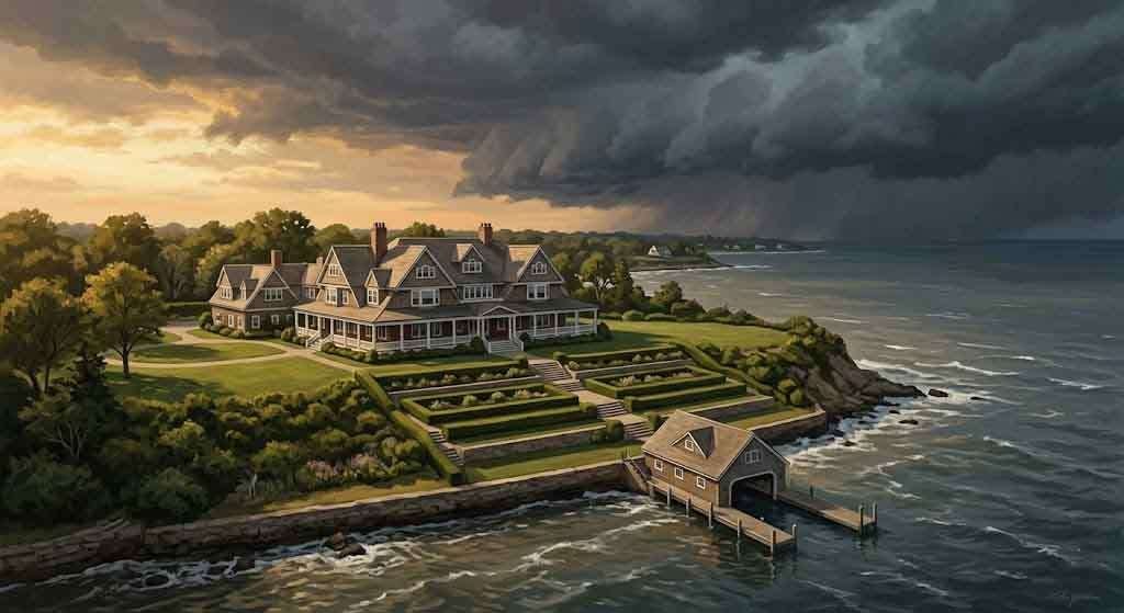
The Gold Coast Before the Storm
To understand what was lost, you need to understand what was there. The 1920s and early 1930s had been the apex of the Gold Coast era on Long Island’s North Shore — the period F. Scott Fitzgerald was writing about when he described the lavish mansions visible from Nick Carraway’s rented cottage in West Egg. By 1938, many of the great estates were already in partial decline. The Depression had done economic damage; the death duties on inherited wealth were gutting the fortunes that sustained 100-room houses on 200-acre grounds.
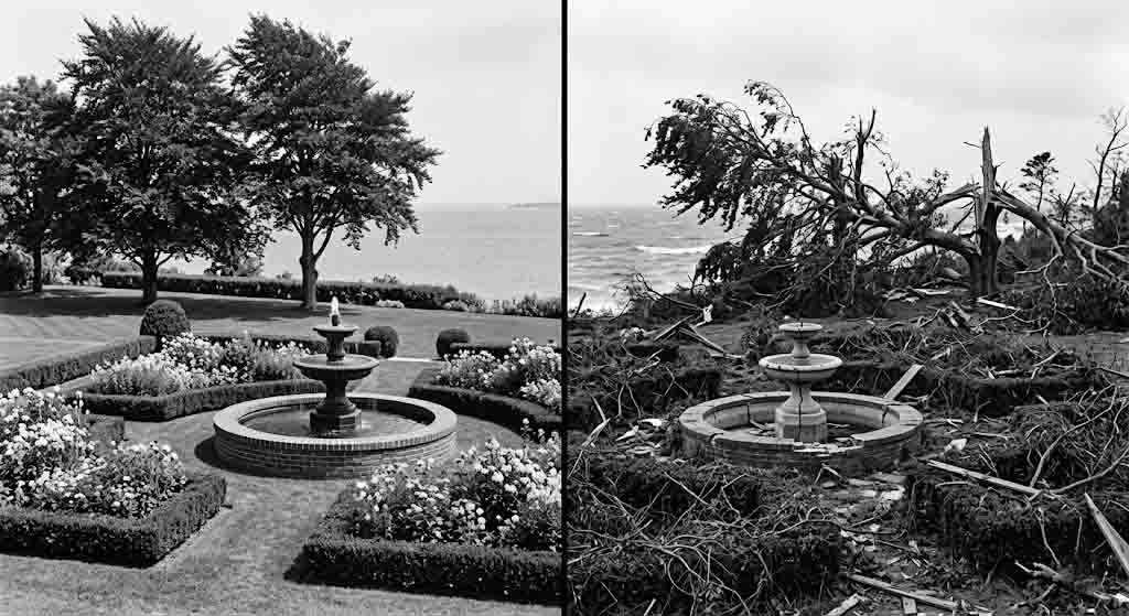
But they were still there. The North Shore between Bayville, Oyster Bay, Cold Spring Harbor, and the bluffs above Eatons Neck held dozens of estates built in the Gilded Age and maintained through the early 20th century — shingle-style summer palaces, formal Italian gardens stepping down to the water, boathouses the size of small hotels, and private docks where steam yachts had once moored.
What the storm could not destroy financially, it destroyed physically. Waterfront structures — the boathouses, the dock houses, the servants’ quarters nearest the shore, the garden pavilions and gazebos — were hit hardest. Some main houses survived with structural damage. Many outbuildings and associated structures did not. At the Oyster Bay estates, the storm surge came off Cold Spring Harbor and Oyster Bay Harbor with enough force to buckle dock structures and flood lower levels. Gardens that had taken decades to establish were shredded. Trees that had been planted in the 1880s came down.
The damage was not always dramatic enough to make the newspapers individually. These were private estates. The owners had the resources to begin repairs without public record. But the destruction was, in aggregate, enormous — and it arrived on top of an economic decline that was already making these properties impossible to maintain.
What Came After
The pattern that followed the storm was predictable in retrospect. Estates that had been struggling to sustain themselves found a hurricane-damaged property even harder to justify. Insurance payouts helped some owners repair; others sold. The late 1930s and early 1940s began the long dismemberment of the Gold Coast — a process that the 1938 hurricane accelerated and that postwar taxation, the democratization of the suburbs, and the general collapse of the servant economy finished.
By the 1950s and 1960s, the great estates were being subdivided by the dozens. The William K. Vanderbilt Jr. estate had already become a county park. The Otto Kahn estate at Cold Spring Harbor became Oheka Castle, later a catering venue. Many others simply disappeared into the lots of the postwar subdivisions that now cover what was once private waterfront in Oyster Bay, Centerport, Northport, and the Eatons Neck peninsula.
Stand at the end of Eatons Neck Road today and look back at the bluff line. There are houses there now that are substantial by any ordinary measure. But the scale of what stood there before — the scope of the landscape, the sequence of formal terraces running down to the Sound — is gone. Some of what you’re looking at was always there: the bluff, the water, the angle of the light on the Sound in September. Some of what you’re looking at replaced something else entirely.
Reading the Landscape
The physical evidence of the Gold Coast period survives in fragments. Gateposts with no gates. A stone wall running through a suburban backyard with no logical origin. A stand of mature copper beeches — not native, not self-seeded, clearly planted — at the edge of a property that now holds a 1960s ranch house. A brick-lined cistern in a basement that predates the current structure by sixty years.
When I drive Route 25A through the North Shore, I notice these things. The landscape is layered. What looks like a quiet residential stretch between Cold Spring Harbor and Oyster Bay has a completely different history a hundred years back. Knowing that the 1938 hurricane was one of the hinge moments — one of the physical events that pushed those estates toward their eventual end — changes how you read it.
The hurricane didn’t cause the death of the Gold Coast. Depression taxes and servant economy collapse and postwar suburbanization would have done that anyway. What the storm did was accelerate the timeline and, in a few specific cases along the bluff lines and harbor edges, physically remove the evidence. Some of what was gone after September 21, 1938, was never rebuilt. It was just gone.
The Lesson That Didn’t Take
Every decade or two, a significant storm reminds Long Island what 1938 looked like. Hurricane Gloria in 1985. Hurricane Bob in 1991. Superstorm Sandy in 2012. Each time, the Sound coast takes damage, the insurance industry recalibrates, and people rebuild. Climate researchers have made the math explicit: a storm of the 1938 class arriving today, when the North Shore is far more densely developed than it was in 1938, would be the most expensive natural disaster in American history. The $70 billion estimate is not alarmism. It is arithmetic.
The 1938 storm created Shinnecock Inlet and widened Moriches Inlet, permanently changing the geometry of Long Island’s south shore. It leveled the locust trees on Christian Avenue in Stony Brook. It sent hundreds of boats into the Port Washington seawall. It damaged the Morgan estate in Glen Cove and flooded the Mayor’s cottage in Northport and killed roughly 100 people on Long Island alone, with another 600 deaths continuing up through New England as the storm accelerated north.
For more on Long Island’s relationship with its waterfront — the history embedded in the coastline and the communities it built — see The Old Field Point Lighthouse: Granite, Gale, and the Conscience of Long Island Sound and The Wreck of the Lexington: The 1840 Steamship Fire That Changed American Maritime Law Forever.
None of that changes the fundamental situation: the Gold Coast is gone. What replaced it is a different kind of wealth, distributed more broadly and built closer to the water than it ever should have been. The next major storm will not find empty estates and summer cottages. It will find a fully developed coastline with millions of people on it and no more warning systems than Charles Pierce had on September 21, 1938 — if they’re not paying attention.
You Might Also Like:
The Old Field Point Lighthouse: Granite, Gale, and the Conscience of Long Island Sound
Rum Row and the Freeport Bootleggers: Long Island’s Clandestine War on the Water
The Vaudeville Summer Colony of St. James: How Stage and Screen Legends Transformed a Quiet North Shore Village Into a High-Society Retreat
Sources:
1938 New England Hurricane — Wikipedia
NOAA Climate.gov — A Hurricane in New England?
HISTORY.com — The Great New England Hurricane, September 21, 1938
Scott Mandia / SUNY Suffolk — The Great Hurricane of 1938
TBR News Media — History Close at Hand: The Long Island Express (September 2023)
New England Historical Society — The Great 1938 Hurricane
1 Degree Outside — Anniversary of the Great New England Hurricane of 1938 (2024)
Liberty Street Economics — Historical Echoes: The Aftermath of a Devastating Hurricane in 1938
NY State Troopers — Hurricane of 1938