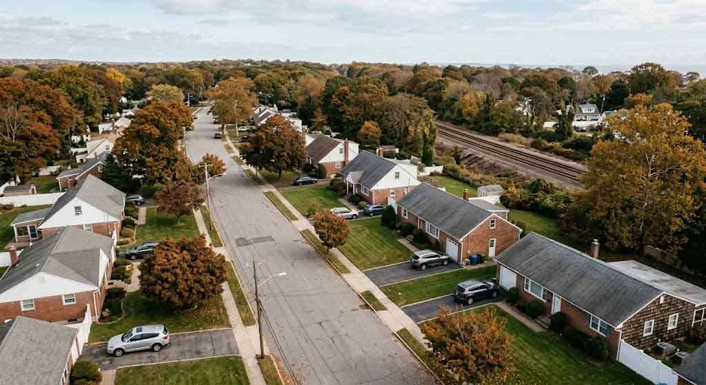
There’s a reason certain streets flood every time it rains and your basement has that inexplicable draft. It’s not bad luck and it’s not the water table. In some cases, it’s infrastructure — cold, iron, nineteenth-century infrastructure — buried under the subdivisions nobody told you were sitting on top of it.
Long Island’s railroad history gets plenty of sentimental treatment. The LIRR is America’s busiest commuter railroad. People write warmly about the old station houses, the depot architecture, the branch lines that once threaded through the Pine Barrens. What they don’t write about as often is the underground layer of that same system — the freight spurs, coal chutes, service tunnels, and drainage culverts built between roughly 1880 and 1945 that never got demolished when the lines were rationalized. They got paved over. Built on. Forgotten.
Some of them are still there.
The Freight Network Nobody Remembers
The LIRR we know today is a passenger railroad. But for the first sixty years of the twentieth century, it ran substantial freight operations alongside its commuter lines. Every town of any commercial size on the North Shore — Smithtown, St. James, Port Jefferson, Huntington, Northport — had at least one freight spur serving coal dealers, lumberyards, ice houses, and agricultural operations. These were not main-line tracks. They were short, often unglamorous connections that ran from the main LIRR corridor into the industrial and commercial heart of a town, typically parallel to a stream or road cut.
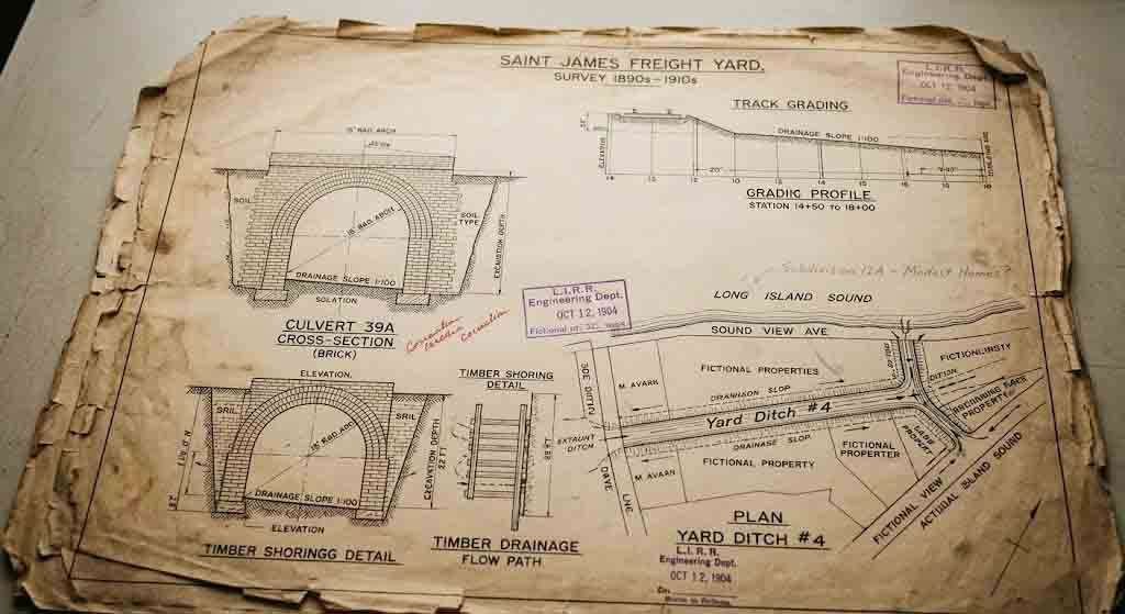
The St. James freight spur, for example, ran southeast of the main Port Jefferson Branch to serve the mill and grain operations that predated the suburb. The Smithtown yards handled coal distribution for the better part of four decades, which meant not just track but unloading infrastructure — trestles, coal bins, gravity chutes, and in some cases bricked drainage tunnels to manage runoff from the yard operations. When the freight business dried up after World War II and diesel replaced coal for residential heating, the yards closed. But the drainage and infrastructure built to serve them didn’t just evaporate.
This is the part that tends to surprise people. When a railroad closes a freight yard, it doesn’t excavate every drainage tunnel and brick culvert it built. It removes the tracks, grades the surface, and moves on. In the postwar Long Island building boom — the same one that turned farms into Levittowns — developers bought those former yard properties and graded right over what was underneath.
What’s Actually Down There
The terminology matters here, because “tunnel” conjures something grand — commuters, tiles, arched ceilings. What we’re talking about is more prosaic but no less real. The underground remnants of LIRR freight infrastructure fall into a few categories.
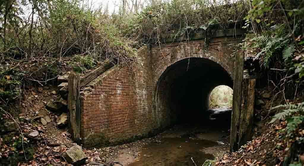
Brick drainage culverts are the most common. Railroad beds require aggressive water management — a flooded cut can destabilize track in hours — so the LIRR and its contractors built brick-arched culverts beneath freight yards and through natural drainage paths wherever the track crossed low ground. Many of these are 18 to 36 inches in diameter, brick-lined, functional to this day as drainage infrastructure, and completely unknown to the people whose property they pass under. In periods of heavy rain, they’re carrying water. The flooding mystery on certain North Shore streets isn’t always about storm drain capacity — sometimes it’s about a 120-year-old brick culvert that’s partially collapsed three lots away.
Coal delivery infrastructure is the second category. Wherever a coal yard operated, there were structures designed to move coal from rail cars to delivery wagons to basements. On Long Island’s North Shore this typically meant elevated trestles over which rail cars would roll, gravity chutes down which coal would fall into below-grade storage bins, and access passages that connected those bins to wagon loading platforms. The bins were often brick-lined and partially or fully subterranean. When the coal operations ceased, these structures weren’t demolished — excavation was expensive and the land was worth more developed than excavated. They were capped, filled to grade, and forgotten.
Service trenches and cable runs form the third category. Railroad operations in the steam and early diesel era required extensive communication infrastructure — telegraph lines, later telephone lines, signal systems. These ran in buried conduits alongside the track, and the conduits didn’t stop at the property line. In several documented cases on the North Shore, former signal conduits extended beneath what became private driveways and foundations when railroad property was subdivided.
The Smithtown Yards and What the County Maps Don’t Show
The most concentrated example of buried freight infrastructure on the central North Shore is the former Smithtown freight operation, which functioned at varying scales from the 1890s until the late 1940s. The Smithtown station sits at the junction of several roads that date to the colonial period, and the railroad came through on a grade that required significant cut-and-fill work when the branch was extended. That fill work buried at least two natural drainage channels. The railroad then built its own culvert system to manage what those channels had previously handled naturally.
Suffolk County maintains drainage infrastructure records, but those records are organized by current road and parcel — not by historic infrastructure that predates subdivision. The result is that County engineers know about the culverts they maintain, but have no systematic record of culverts that exist on private property or beneath roads they weren’t built to maintain. The LIRR’s own historical records, many of which ended up in the collections of the Long Island Rail Road Historical Society, document some of this infrastructure in engineering drawings that nobody is cross-referencing against current property maps.
The Long Island History: 20 Moments That Shaped the Island pillar puts railroad expansion in its proper context — the LIRR wasn’t just transportation, it was the engine of Long Island’s transformation from agricultural peninsula to suburban continent. That transformation left physical residue in ways that are still sorting themselves out.
How GPR and LiDAR Are Changing What We Know
For most of the twentieth century, the only way to know what was beneath a piece of land was to dig, and nobody was digging in suburban backyards looking for old culverts. That’s changed. Ground-penetrating radar, which bounces electromagnetic pulses off subsurface features and maps their depth and character, has become standard equipment for archaeological investigation and increasingly accessible to environmental engineers and large-scale property developers.
The intersection of GPR surveying and historical records is where the interesting discoveries have been happening. A GPR sweep of a North Shore property that shows a linear anomaly at a consistent depth of four to six feet, running parallel to an old road cut — and cross-referenced against an 1895 railroad engineering drawing showing a drainage culvert at that exact alignment — is not a coincidence. It’s infrastructure.
The When Folklore Meets LiDAR post covers what modern remote sensing technology is doing to our understanding of Long Island’s pre-colonial landscape. The same tools apply to the industrial archaeology of the railroad era, and the findings are often just as surprising.
The problem is that GPR surveys are expensive and nobody is systematically applying them to the question of buried railroad infrastructure on suburban Long Island. They happen incidentally — during utility work, during foundation investigations for new construction, during environmental assessments. When they turn up something anomalous, the finding gets recorded in an engineering report that nobody reads.
The Basement Draft Problem
If you have an older house — built between 1950 and 1970 — in a neighborhood that was railroad or freight-adjacent, and you have an unexplained draft in your basement, there’s a reasonable but underappreciated explanation. Brick culverts and brick-lined coal bins that are partially open to grade create natural convection systems. Cold air enters through any ground-level opening, follows the brick tunnel, and exits wherever there’s a temperature differential. If that brick work passes within a few feet of your foundation, and if your foundation has any porosity — which most pre-1970 poured concrete foundations do — you have a direct pathway.
This is not a scare story. Structurally, the old brick culverts are not generally dangerous. They’re not tunnels a person could walk through and they’re not creating sinkholes. They’re more like buried pipes — they carry water when it rains, they sit static when it doesn’t, and they’ve been doing so for over a century. The concern is not collapse risk but rather moisture and air movement, both of which affect energy efficiency and basement habitability in ways that no amount of weatherstripping will solve if the source is 40 feet underground.
What You Can Actually Do
If you own an older property on the North Shore — particularly near former rail lines in Smithtown, Kings Park, Northport, St. James, or Port Jefferson — and you have recurring drainage issues or basement anomalies, there are practical steps. The Long Island Rail Road Historical Society maintains archives of historical engineering drawings, and the Suffolk County Department of Public Works keeps old drainage records that sometimes reference railroad-era infrastructure. The Library of Congress holds HABS (Historic American Buildings Survey) and HAER (Historic American Engineering Record) documentation for some Long Island railroad structures, though coverage is uneven.
A title search that goes back to the railroad era — not just the standard 60-year search — will sometimes reveal easements and drainage rights that the LIRR held and never formally extinguished when freight operations ended. Those easements can affect what a property owner can build and where, and many Long Island homeowners have them on their deeds without knowing it.
The Monarch in the Wall post gets at something true about this place: Long Island has more hidden history per square mile than most people realize, and a lot of it is literally underfoot. The railroad didn’t just change how people got around. It changed what was buried beneath the ground they built their houses on.
Engineering Archaeology as Local Practice
The larger discipline here has a name — industrial archaeology — and it’s taken more seriously in Britain than in the United States, where we tend to regard old infrastructure as waste rather than record. The British have entire preservation frameworks for canal tunnels, mine shafts, and railway earthworks that Americans would simply demolish. On Long Island, the closest analog is the growing interest in documenting the island’s pre-suburban agricultural landscape — the fieldstone walls, the mill ponds, the ferry crossings — before the last evidence disappears.
The railroad infrastructure is the industrial chapter of that same story. Culverts built by Irish immigrant labor in 1895, brick-lined by hand, carrying rainwater beneath streets named after the families who sold their farmland to the railroad — that’s Long Island in concentrated form. The fact that most of it is invisible doesn’t make it less real. It makes it more worth finding.
You Might Also Like:
- The Culper Ring of Setauket: How a Village on Long Island’s North Shore Outmaneuvered the British Empire
- When Folklore Meets LiDAR: The Science of Legendary Walls and the Prehistoric Origins of Sunken Cities
- The Ground Beneath the Tower: Shoreham, New York, and the World Nikola Tesla Almost Built
Sources:
- Long Island Rail Road Historical Society Archive: www.lirrhistory.com
- Library of Congress, Historic American Engineering Record (HAER): www.loc.gov/collections/historic-american-engineering-record
- Suffolk County Department of Public Works, Drainage Infrastructure Records: www.suffolkcountyny.gov/Departments/Public-Works
- Seyfried, Vincent F. The Long Island Rail Road: A Comprehensive History. Garden City, NY: 1963–1975.
- United States Geological Survey, Long Island Water Science Center: www.usgs.gov/centers/new-york-water-science-center
- Industrial Archaeology Review, published by the Association for Industrial Archaeology: www.industrial-archaeology.org